


A short boat ride from Leland rises the historic Manitou islands, which hold the opportunity for a scenic hiking or camping trip.
North Manitou Island has just over 20 miles worth of trails, with the main loop measuring to 13.3 miles. South Manitou has roughly 17 miles of hiking trails and premitive roads that has another surprise around every corner.
The Island was hit hard by an ice storm that missed the mainland of Leelanau and plagued other areas of the state back in March.
In May a crew from the Indiana dunes area came up to help and work on trails.
The village and docks are closed due to several disputes and projects, but if you can get there the journey makes it all worth while.
Hikers may find some down trees on a lot of trails, especially in wilderness due to that ice storm While on the island, there are several ruins of a once growing civilization.
When you land at the village dock on the island, the first buildings seen are the left over U.S. Life-Saving Service Complex, which was set up to provide aid to ships in distress while traveling through the Manitou Passage.
Right behind the complex, is a line up of buildings that is called Cottage Row, which was constructed between 1893 and 1924.
The land was owned by Silas Boardman, who went to the island for health reasons. His daughter Carrie and her husband, George Blossom, visited with friends, who bought land off Boardman to build cottages and vacation together.
As a hiker walks south, the hiker will come up on the old school and eventually the cemetery, which still has visible grave markers. Once the cemetery is reached, the main loop starts heading west, but ahead are dunes which have certain boundaries for the Piping Plover nesting area.
On these dunes, old power lines can be found, along with the occasional remains scattered in the dune.
Staying on the main loop, there are a couple homesteads that aren’t visible besides the clearing they stood in, except for the Bournique’s.
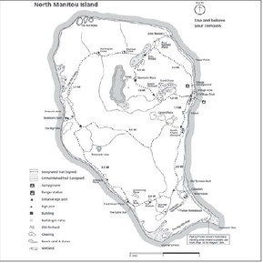
Fat Annie’s homestead has been overtaken by wilderness.
As the hiker starts heading north, the Johnson place will be along the path, which remnants of the apple and pear orchards are visible if looked at carefully.
This is a couple miles before Tamarack Lake, one of the two lakes on the island.
After Tamarack Lake, there is a trail that leads back to the village area, where a dock rests unused, or there is a trail that continues north towards Swenson’s barn, and Crescent City, the other settlement on the island.
Swenson’s barn is one of the last standing buildings on the island.
Crescent City started when a dock was built on the west shore of the island. It grew to a small settlement when the sawmill was built. With the village continuing to grow, it was deemed necessary for a school. In the early 1900s, the population grew to 300 residents.
The town faded away once the mills shut down in 1917, as the lumber industry collapsed.
Past the abandoned settlement is the Old Grade, which is the railroad bed that is left from transporting lumber from forests to the docks in Crescent City. These lead to more lumber camps and the potholes.
The first camp is the Davenport Camp, located northwest of Lake Manitou, the second lake on the island, which has a trail moving south and around the lake and more farm remains back to the village dock. Following the main trail, brings the hiker to Stormer Camp, which is a graveyard of logging trucks with remains of the old timber industry. The trucks were abandoned from a second attempt of logging on the island, which lasted from 19561970.
A little past the second camp and over a bridge, is the Paul Maleksi and John Maleski place, where only the clearing is still visible. This is the last possible remains before completing the loop and returning to the Village area and the campground.
The campground has only eight spots available on a first come first serve basis, but can fit two tents with a max of ten people per party.
South Manitou Island
Located three miles south is South Manitou Island, which is open this summer and has been cleaned up from the ice storms this winter.
When the boat docks at the smaller island, hikers will see the village which has the ranger station, which was originally built for the U.S. Life-Saving Service.
The rest of the buildings in the village are listed on the register of historic places, some were used as a general store, post office, or houses.
The campground is down the trail along the bay.
The lighthouse is half a mile walk just off the unpaved road. Further down the trail the lighthouse is on, is one of the the campgrounds on the island, along with Florence Lake, the only lake on the island.
A little past Florence Lake is the wreck of the Francisco Morazan, located only 2.5 miles from the dock.
The freighter sank in November of 1960 while it was fighting strong wind and waves causing the crew’s position to be off by more than 70 miles. Just down the trail from the bluff overlooking the shipwreck, is the Old Growth Cedars which are twice as large as the average size.
Heading the other way at Florence Lake will bring the hikers to the one-room school house, which also acted as a social place on the island. A little past the school house is the cemetery, and the farm loop which has two farmsteads that survive today.
One of the most popular hikes on the island is hiking the beach around the island, which is 10 miles and hikers can still see attractions like the lighthouse, Francisco Morazan, bluffs along the western shore, and Popple Campground. Gull Point is offlimits to humans as it is a protected nesting place for Herring and Ring-Billed gulls.